


Valmorel La Montagne de têtee

ARPF
User
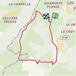

Length
7.4 km

Max alt
1734 m

Uphill gradient
403 m
Km-Effort
12.8 km

Min alt
1337 m

Downhill gradient
411 m
Boucle
Yes
Creation date :
2019-01-15 13:00:37.197
Updated on :
2019-01-15 13:00:37.197
2h35
Difficulty : Easy

FREE GPS app for hiking
 SityTrail
IGN / Geographical institutes
SityTrail Plus
The world is yours!
About
Trail Walking of 7.4 km to be discovered at Auvergne-Rhône-Alpes, Savoy, Les Avanchers-Valmorel. This trail is proposed by ARPF.
Description
rando facile à Valmorel
Positioning
Country:
France
Region :
Auvergne-Rhône-Alpes
Department/Province :
Savoy
Municipality :
Les Avanchers-Valmorel
Location:
Unknown
Start:(Dec)
Start:(UTM)
299730 ; 5038479 (32T) N.
Comments